I do not envy Martin O'Malley. As chair of the Democratic Governor's Association and presidential aspirant O'Malley is under tremendous pressure to deliver at least one new Democratic House seat to bolster his party's chances of reclaiming the House of Representatives in 2012. The map proposed by his Redistricting Commission bowed to that national pressure.
But the only way to create 7 Democratic districts in Maryland (a state where Republicans routinely win 40% of the statewide vote and dominate every region of the state except central Maryland) is to take the substantial African-American vote in Baltimore City, Montgomery County and Prince Georges County and use those voters to dilute the Republican areas of the state. There is clear evidence of this in the recently proposed map.
Baltimore City voters are used to offset Republican votes in Baltimore County, Howard County, Harford County and Anne Arundel County. Montgomery County voters offset western Maryland (and Anne Arundel, and Baltimore County) and Prince Georges voters dilute Southern Maryland (and Anne Arundel).
This is an effective way to gerrymander a state, but the result is reduced minority voting power. Maryland's population is over 40% minority, but only two of the state's eight Congressional districts are majority-minority (the 4th and 7th). Even though the minority population has grown in the past decade, the new map would not create any additional majority-minority districts. Worse, it would weaken minority voting strength in five districts. Minority vote strength in the two majority-minority districts (the 4th and 7th) would decline slightly and in the 8th district minority vote strength would fall dramatically from roughly 37% to around 25% - all a result of the gerrymandering needed to turn Roscoe Bartlett's red 6th district marginally blue. The 6th district goes from being 10% minority to 22% minority.
Maryland's 1st district would be 15% minority, the 2nd 37% minority, the 3rd 29% minority, and the 5th 44% minority.
But African-American community leaders in Montgomery and Prince Georges counties are not happy with the manner in which the minority population has been divided and used to create Democratic districts. It's a sad reality of American politics that minority candidates, especially African-American candidates, are rarely elected from non majority-minority districts. So all of those districts with 29%, 37% or 44% minority membership simply rely on minority voters to elect white Democrats.
Given Maryland's population and the geographic concentration of minority voters, the state should be home to at least 3, if not 4, majority-minority districts. In light of that, it's easy to understand why minority community leaders are upset with consolation prize of two districts.
The Voting Rights Act of 1965 prevents redistricting that disadvantages minority voters and weakens their political power - based on that, some community leaders have threatened to file a lawsuit to stop the proposed map. The problem for O'Malley is the simple fact that you cannot create 3 or 4 majority-minority districts in Maryland without creating 2 or 3 Republican districts as a byproduct. You can either have more Democrats, but fewer minority representatives or more minority representatives, but fewer Democrats.
This brings us to the other pressure on O'Malley. O'Malley wants to be President - there can be little doubt about that. But to build a foundation for a presidential run, he needs a record of accomplishment as governor - this has eluded him thus far. O'Malley has been a competent and responsible manager of the state, but he needs a record of legislative accomplishment. O'Malley has chosen to take more risks in the coming legislative session by endorsing high profile issues like marriage equality. Marriage equality died in the prior legislative session when an odd alliance of African-American delegates, conservative Democrats, and Republicans joined to kill the measure.
As a voting bloc, African-American senators and delegates wield tremendous power in the General Assembly, and their opposition to O'Malley's agenda (coupled with Assembly Republicans and conservatives) could make the difference between a failed or successful second term. O'Malley knows this. As such, he cannot afford to ignore the rising tide of opposition to the map proposed by his advisory commission.
O'Malley faces a difficult choice - does he represent the interests of the national Democratic party and deliver them an additional seat in Congress (and risk alienating a key party voting bloc in Maryland) or does he represent the interests of the people of Maryland a present a map that respects the growing minority presence in the state (and risk alienating national party leaders whose support he will need if he runs for president).
In his speech before the 2004 Democratic convention O'Malley said "to govern is to choose." Today, he faces a very difficult choice and his decision will likely tell us much about his ambition and whether his focus remains on Maryland or his future plans. And he must decide soon.

Showing posts with label maryland redistricting. Show all posts
Showing posts with label maryland redistricting. Show all posts
Thursday, October 13, 2011
Thursday, October 6, 2011
Race, Redistricting, and a More Reasonable Option?
Update: Please take a moment to tell the Redistricting Commission what you think of their proposal.
Update 2: I tip my hat to the Montgomery County Council for standing up to Governor O'Malley and opposing his gerrymandered mess.
African-American leaders in Maryland are quite justifiably concerned with the recently released Congressional redistricting map prepared by the Governor's Redistricting Commission. As drawn, Maryland will continue to have only two majority-minority districts - the 4th and 7th - and each is likely to have fewer African-American voters.
Though African-Americans compose 30% of the state's population they are heavily concentrated in Baltimore City and county, Montgomery county, and Prince Georges county - combined these four regions are home to 78% of the African-American population (add Charles county and that rises to 82%). With regard to the total population of the state, those four counties are home to only 56% of the state's residents.
The concentrated nature of the African-American population creates a problem for Democrats when redistricting - African-Americans are the most reliable Democratic voting bloc, but the concentration in the central part of the state makes it difficult to offset more conservative voters in western, southern and northern Maryland and on the eastern shore.
The only way to dilute those areas is to create districts that divide the African-American communities and join them with sometimes far-flung conservative areas. In the proposed map (below) one can see that this has been done in the 2nd, 3rd, 4th, 5th, 6th, 7th, and 8th districts. Baltimore City's 620,000 residents are divided among 3 congressional districts - they help to create the majority-minority 7th congressional district, but "surplus" voters are then used to dilute more conservative suburbs in Anne Arundel and Baltimore counties and rural areas of Harford and Baltimore counties. In the last gubernatorial election Democratic incumbent Martin O'Malley won Baltimore city by a margin of 82% to 16% over Republican Bob Ehrlich. The two split the Baltimore county vote. In Anne Arundel, Ehrlich won 54% to 43% and in Harford he won 65% to 34%.
A single, compact and cohesive majority-minority district could be created by by joining all of Baltimore City with its southwest suburbs in Baltimore county - home to much of the county's African-American population. But the results from 2010 gubernatorial election demonstrate why this was not an acceptable option. Republican voters in the surrounding communities needed to be offset. Baltimore City is divided across 3 districts and divided solely for that purpose. To further dilute probable Republican voters Baltimore and Anne Arundel county are divided across 4 districts and Harford across 2.
Prince Georges county, home to 840,000 Marylanders, including 560,000 African-American residents is divided among the 4th and 5th districts. The 4th district is a majority-minority district oddly joined with Anne Arundel county. In the most recent gubernatorial election in Maryland, Prince Georges county voted for O'Malley by a margin of 88% to 11% over Ehrlich. Prince Georges county is over 60% larger than Anne Arundel and with the more Republican Anne Arundel county divided among 4 districts Democratic voters, mostly African-American, from Prince Georges county and Baltimore City neutralize the Republican strength there.
Given the size of Prince Georges county and the large surplus of Democratic votes there, it is then used to dominate the 5th district - home to Minority Whip Steny Hoyer (someone I'm proud to have as my representative in Congress). Charles county voted for O'Malley by a 2-to-1 margin over Ehrlich, but Ehrlich won Calvert and St. Mary's (as well as Anne Arundel) handily. Anne Arundel, Calvert, and St. Mary's counties could form a single congressional district positioned on the western shore of the Bay - but it would be a Republican district.
Montgomery county, with 950,000 residents, voted 68% to 31% for O'Malley and is divided across 3 districts. The 6th congressional district currently includes all of western Maryland, Frederick and Carroll counties, and northern Baltimore and Harford counties. Ehrlich won all of those counties in 2010 and carried the district 62% to 33%.
To counter that Republican advantage, the new map drops most of Frederick county as well as all of Carroll and the sections of Baltimore and Harford counties from the district. They are replaced with a sizable chunk of Montgomery county to create a marginally Democratic district. Much of the rest of Montgomery county is then used to offset the addition of Frederick and Carroll county to the 8th district - with a smidge of Montgomery going to the 3rd district as well.
The net effect of all of this being a new congressional map that will yield 7 Democratic members of Congress (including 2 African-American members) and 1 Republican. Not bad for a state where Republicans routinely receive about 40% of the statewide vote.
But it comes at a cost to minority voters. Not only could Baltimore City and its immediate suburbs form a single majority-minority district, the three DC area counties of Montgomery, Prince Georges, and Charles are home to 46% of the state's African-American population. There is nearly equal divide between African-American and white voters among the three counties, but they are also home to 64% of the state's fast growing Hispanic population - providing a distinct advantage to minority candidates. And that advantage matters as it is a sad but true reality in America that African-American candidates are rarely elected from non majority-minority districts.
Montgomery, Prince Georges, and Charles county could occupy 3 congressional districts - possibly creating 2, or perhaps 3, majority-minority districts in the region. Coupled with the Baltimore City/suburbs region Maryland's Congressional delegation would be home to 3, and quite possibly 4, members of the state's minority population - a reasonable number given that Maryland's population is 40% minority.
The 1st congressional district would encompass the eastern shore and Harford county (and the Hereford zone school district in northern Baltimore County). The sixth congressional district would extend to Carroll county and incorporate bordering neighborhoods on western Baltimore county and north western Howard county as needed to achieve equal population sizes. The rest of Baltimore and Howard county would join in a district (with some of southern Howard joining the Montgomery, Prince Georges, Charles grouping).
Such an approach would also undo the gerrymandered mess created in 2002 and made worse under the current proposal and folks need to stop pretending that the proposed map is not gerrymandered - of course it is. Just look at the new 3rd district (below) and read the related story - and then ask, why is the only available map of the 3rd district a map prepared by the press? Why did the committee refuse to include a map of the 3rd district in its presentation? The answer seems clear - because it's a gerrymandered and indefensible nightmare and its inclusion would then draw attention to the very questionable nature of the other districts.
According to Senate President and advisory committee member Thomas V. Mike Miller Jr. (D-Calvert) "Congressman Sarbanes lived in Baltimore County, but wanted to continue to represent the capital city Annapolis." This of course is the root of the problem. In a democracy, the people are supposed to go to the polls and select their representative. Under the process just completed, the Redistricting Commission let the representatives select their constituents. But of course not all representatives were afforded such an accommodation. I doubt Roscoe Bartlett asked to have his district fundamentally reconfigured and I suspect any request to keep Frederick and Carroll counties would have been ignored. Essentially, Miller confessed to partisan gerrymandering.
Miller's peculiar statements continued as he argued "Maryland is a small state ... and it doesn’t have many rural, conservative areas that would vote for Republicans that could comprise a district of 700,000 people." This is of course wrong, especially if you include the suburban areas that Republicans often carry. Has Miller reviewed election returns from Baltimore county? Garrett, Allegheny, Washington, Frederick and Carroll counties? St. Mary's, Calvert, and Anne Arundel county? The entire Eastern shore and Harford county? The reason the proposed map is so gerrymandered is because Maryland is full of regions that would and do vote Republican and these regions surround four counties and Baltimore City that vote Democratic. Democrats are the clear majority party in Maryland - but its hardly a one party state.
Finally, Miller defended the proposed map, arguing "the change is quite modest." It's hard to reconcile that claim with the fact that only 174,000 Marylanders actually needed to be moved in order to create districts with equal populations. The Commission's plan would move over 1.5 million Marylanders - nearly a third of the state's residents.
But, if the Commissioners are open to a moving 1.5 million people to balance out 174,000 why not consider a radical idea - a map that actually represents Maryland.
Below is a very rough depiction of what a more reasonable and representative map might look like (note that the final boundaries would shift a little to balance out district sizes and to maximize minority representation in the 4th, 7th, and 8th districts - but this is essentially a map with 8 roughly equal districts).
All remnants of past gerrymandering would be gone. I'd also point out that this map intentionally fails to consider whether current incumbents would be redistricted out of their districts - for one simple reason - congressional districts belong to the people and not to a member of Congress.
The map that I've developed and just described would create a Congressional delegation of 4 Democrats (3rd, 4th, 7th and 8th) and 3 Republicans (1st, 5th, and 6th). The 2nd District would be a swing district (O'Malley carried Howard county by 10 points) likely leaning Democratic as the more conservative areas in Howard and Baltimore counties are in the 6th district. Howard and Baltimore are two counties that should be divided over more than one district given there very diverse demographics (a reflection of their central location), but this requires careful slices, not zig-zag slicing and dicing.
As I've demonstrated in the past, Maryland is a 60/40 Democrat/Republican state - a 5/3 Democrat/Republican delegation would be 62.5% Democrat and 37.5% Republican. The state's geographic, political, and ethnic diversity would be more accurately represented. Minority voters would no longer be denied the opportunity to maximize representation and Maryland would have a map that lets voters pick the best person to represent their communities - as opposed to the current practice in which representatives pick the communities and voters most likely to vote for them.
I of course realize that my proposal or any similar proposal would go no where. The Democratic and Republican parties are engaged in a heated battle to pick up or protect seats anywhere the can. Maryland is one of the few states where redistricting is controlled by the Democrats and there is no way the party would accept a map that would elect more Republicans.
But a redistricting process that is based entirely on maximizing partisan advantage, regardless of the true diversity of a state, undermines the whole concept of representation. It renders the House of Representative nothing more than a tool of the two parties rather than a microcosm of the people. So far, 7 states have abandoned partisan redistricting. In California, the gerrymandering was so bad that in the span of a decade out of 53 congressional seats, across 5 elections (that's 265 distinct elections) there was only one instance (1/265 = 0.38%) when a seat changed parties. That's not democracy. With the state's newly drawn (non-partisan) map, fully 14 of the state's 53 seats are toss-ups - from 0.38% across a decade to possibly 26% in a single election - that's change we can believe in.
In his new book, The Price of Civilization, Jeffrey Sachs rightly describes America not as a democracy but rather as a duopoly controlled by the two parties. It is managed competition in which Democrats have drawn their way to a floor of about 195 seats in the House and Republicans about 185. It is a world where 380 of the House's 435 seats are not competitive. A century ago the progressive movement stood for the end to the corruption of government, it sought to break the hold of party machines and bosses, it sought to return integrity to the political system. The movement needs to rediscover its roots. We need to move beyond the short term obsession over whether a given choice or change helps or hurts Democrats or Republicans and instead focus on the long term objective of doing what is needed to maintain the health and vitality of our democracy. An end to partisan gerrymandering would be a good start (then we can follow that up by ending closed primaries and enacting public financing of campaigns).
Update 2: I tip my hat to the Montgomery County Council for standing up to Governor O'Malley and opposing his gerrymandered mess.
African-American leaders in Maryland are quite justifiably concerned with the recently released Congressional redistricting map prepared by the Governor's Redistricting Commission. As drawn, Maryland will continue to have only two majority-minority districts - the 4th and 7th - and each is likely to have fewer African-American voters.
Though African-Americans compose 30% of the state's population they are heavily concentrated in Baltimore City and county, Montgomery county, and Prince Georges county - combined these four regions are home to 78% of the African-American population (add Charles county and that rises to 82%). With regard to the total population of the state, those four counties are home to only 56% of the state's residents.
The concentrated nature of the African-American population creates a problem for Democrats when redistricting - African-Americans are the most reliable Democratic voting bloc, but the concentration in the central part of the state makes it difficult to offset more conservative voters in western, southern and northern Maryland and on the eastern shore.
The only way to dilute those areas is to create districts that divide the African-American communities and join them with sometimes far-flung conservative areas. In the proposed map (below) one can see that this has been done in the 2nd, 3rd, 4th, 5th, 6th, 7th, and 8th districts. Baltimore City's 620,000 residents are divided among 3 congressional districts - they help to create the majority-minority 7th congressional district, but "surplus" voters are then used to dilute more conservative suburbs in Anne Arundel and Baltimore counties and rural areas of Harford and Baltimore counties. In the last gubernatorial election Democratic incumbent Martin O'Malley won Baltimore city by a margin of 82% to 16% over Republican Bob Ehrlich. The two split the Baltimore county vote. In Anne Arundel, Ehrlich won 54% to 43% and in Harford he won 65% to 34%.
A single, compact and cohesive majority-minority district could be created by by joining all of Baltimore City with its southwest suburbs in Baltimore county - home to much of the county's African-American population. But the results from 2010 gubernatorial election demonstrate why this was not an acceptable option. Republican voters in the surrounding communities needed to be offset. Baltimore City is divided across 3 districts and divided solely for that purpose. To further dilute probable Republican voters Baltimore and Anne Arundel county are divided across 4 districts and Harford across 2.
 |
| Proposed Congressional District Map from Redistricting Commission |
Prince Georges county, home to 840,000 Marylanders, including 560,000 African-American residents is divided among the 4th and 5th districts. The 4th district is a majority-minority district oddly joined with Anne Arundel county. In the most recent gubernatorial election in Maryland, Prince Georges county voted for O'Malley by a margin of 88% to 11% over Ehrlich. Prince Georges county is over 60% larger than Anne Arundel and with the more Republican Anne Arundel county divided among 4 districts Democratic voters, mostly African-American, from Prince Georges county and Baltimore City neutralize the Republican strength there.
Given the size of Prince Georges county and the large surplus of Democratic votes there, it is then used to dominate the 5th district - home to Minority Whip Steny Hoyer (someone I'm proud to have as my representative in Congress). Charles county voted for O'Malley by a 2-to-1 margin over Ehrlich, but Ehrlich won Calvert and St. Mary's (as well as Anne Arundel) handily. Anne Arundel, Calvert, and St. Mary's counties could form a single congressional district positioned on the western shore of the Bay - but it would be a Republican district.
Montgomery county, with 950,000 residents, voted 68% to 31% for O'Malley and is divided across 3 districts. The 6th congressional district currently includes all of western Maryland, Frederick and Carroll counties, and northern Baltimore and Harford counties. Ehrlich won all of those counties in 2010 and carried the district 62% to 33%.
To counter that Republican advantage, the new map drops most of Frederick county as well as all of Carroll and the sections of Baltimore and Harford counties from the district. They are replaced with a sizable chunk of Montgomery county to create a marginally Democratic district. Much of the rest of Montgomery county is then used to offset the addition of Frederick and Carroll county to the 8th district - with a smidge of Montgomery going to the 3rd district as well.
The net effect of all of this being a new congressional map that will yield 7 Democratic members of Congress (including 2 African-American members) and 1 Republican. Not bad for a state where Republicans routinely receive about 40% of the statewide vote.
But it comes at a cost to minority voters. Not only could Baltimore City and its immediate suburbs form a single majority-minority district, the three DC area counties of Montgomery, Prince Georges, and Charles are home to 46% of the state's African-American population. There is nearly equal divide between African-American and white voters among the three counties, but they are also home to 64% of the state's fast growing Hispanic population - providing a distinct advantage to minority candidates. And that advantage matters as it is a sad but true reality in America that African-American candidates are rarely elected from non majority-minority districts.
Montgomery, Prince Georges, and Charles county could occupy 3 congressional districts - possibly creating 2, or perhaps 3, majority-minority districts in the region. Coupled with the Baltimore City/suburbs region Maryland's Congressional delegation would be home to 3, and quite possibly 4, members of the state's minority population - a reasonable number given that Maryland's population is 40% minority.
The 1st congressional district would encompass the eastern shore and Harford county (and the Hereford zone school district in northern Baltimore County). The sixth congressional district would extend to Carroll county and incorporate bordering neighborhoods on western Baltimore county and north western Howard county as needed to achieve equal population sizes. The rest of Baltimore and Howard county would join in a district (with some of southern Howard joining the Montgomery, Prince Georges, Charles grouping).
Such an approach would also undo the gerrymandered mess created in 2002 and made worse under the current proposal and folks need to stop pretending that the proposed map is not gerrymandered - of course it is. Just look at the new 3rd district (below) and read the related story - and then ask, why is the only available map of the 3rd district a map prepared by the press? Why did the committee refuse to include a map of the 3rd district in its presentation? The answer seems clear - because it's a gerrymandered and indefensible nightmare and its inclusion would then draw attention to the very questionable nature of the other districts.
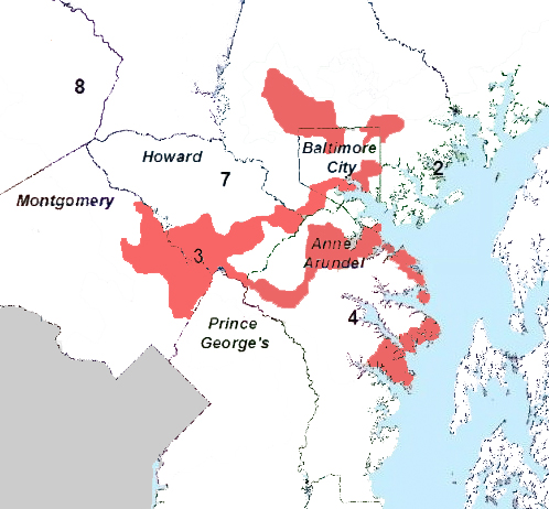 |
| Maryland's New 3rd District |
Miller's peculiar statements continued as he argued "Maryland is a small state ... and it doesn’t have many rural, conservative areas that would vote for Republicans that could comprise a district of 700,000 people." This is of course wrong, especially if you include the suburban areas that Republicans often carry. Has Miller reviewed election returns from Baltimore county? Garrett, Allegheny, Washington, Frederick and Carroll counties? St. Mary's, Calvert, and Anne Arundel county? The entire Eastern shore and Harford county? The reason the proposed map is so gerrymandered is because Maryland is full of regions that would and do vote Republican and these regions surround four counties and Baltimore City that vote Democratic. Democrats are the clear majority party in Maryland - but its hardly a one party state.
Finally, Miller defended the proposed map, arguing "the change is quite modest." It's hard to reconcile that claim with the fact that only 174,000 Marylanders actually needed to be moved in order to create districts with equal populations. The Commission's plan would move over 1.5 million Marylanders - nearly a third of the state's residents.
But, if the Commissioners are open to a moving 1.5 million people to balance out 174,000 why not consider a radical idea - a map that actually represents Maryland.
Below is a very rough depiction of what a more reasonable and representative map might look like (note that the final boundaries would shift a little to balance out district sizes and to maximize minority representation in the 4th, 7th, and 8th districts - but this is essentially a map with 8 roughly equal districts).
 |
| Eberly Concept Redistricting Map |
The map that I've developed and just described would create a Congressional delegation of 4 Democrats (3rd, 4th, 7th and 8th) and 3 Republicans (1st, 5th, and 6th). The 2nd District would be a swing district (O'Malley carried Howard county by 10 points) likely leaning Democratic as the more conservative areas in Howard and Baltimore counties are in the 6th district. Howard and Baltimore are two counties that should be divided over more than one district given there very diverse demographics (a reflection of their central location), but this requires careful slices, not zig-zag slicing and dicing.
As I've demonstrated in the past, Maryland is a 60/40 Democrat/Republican state - a 5/3 Democrat/Republican delegation would be 62.5% Democrat and 37.5% Republican. The state's geographic, political, and ethnic diversity would be more accurately represented. Minority voters would no longer be denied the opportunity to maximize representation and Maryland would have a map that lets voters pick the best person to represent their communities - as opposed to the current practice in which representatives pick the communities and voters most likely to vote for them.
I of course realize that my proposal or any similar proposal would go no where. The Democratic and Republican parties are engaged in a heated battle to pick up or protect seats anywhere the can. Maryland is one of the few states where redistricting is controlled by the Democrats and there is no way the party would accept a map that would elect more Republicans.
But a redistricting process that is based entirely on maximizing partisan advantage, regardless of the true diversity of a state, undermines the whole concept of representation. It renders the House of Representative nothing more than a tool of the two parties rather than a microcosm of the people. So far, 7 states have abandoned partisan redistricting. In California, the gerrymandering was so bad that in the span of a decade out of 53 congressional seats, across 5 elections (that's 265 distinct elections) there was only one instance (1/265 = 0.38%) when a seat changed parties. That's not democracy. With the state's newly drawn (non-partisan) map, fully 14 of the state's 53 seats are toss-ups - from 0.38% across a decade to possibly 26% in a single election - that's change we can believe in.
In his new book, The Price of Civilization, Jeffrey Sachs rightly describes America not as a democracy but rather as a duopoly controlled by the two parties. It is managed competition in which Democrats have drawn their way to a floor of about 195 seats in the House and Republicans about 185. It is a world where 380 of the House's 435 seats are not competitive. A century ago the progressive movement stood for the end to the corruption of government, it sought to break the hold of party machines and bosses, it sought to return integrity to the political system. The movement needs to rediscover its roots. We need to move beyond the short term obsession over whether a given choice or change helps or hurts Democrats or Republicans and instead focus on the long term objective of doing what is needed to maintain the health and vitality of our democracy. An end to partisan gerrymandering would be a good start (then we can follow that up by ending closed primaries and enacting public financing of campaigns).


Monday, October 3, 2011
Redistricting Commission Releases Proposed Map
Update: Want to learn more about gerrymandering and ask me questions? Come to St. mary's College on October 12 for a screening of the documentary "Gerrymandering."
The Redistricting Commission has officially released its map - as shown below, the proposed map is a variation of Option 1, as detailed in a prior post and in the Washington Post.
 Democrats appear to have abandoned plans to target both the 1st and 6th congressional districts and have opted instead to target only the 6th and to make the 1st even more solidly Republican - a common tactic in Gerrymandering.
Prior to this map, Maryland was home to two of the most egregious examples of gerrymandering in the nation: the 2nd and 3rd congressional districts. If adopted, the newly drawn 4th, 7th and 8th will join their ranks. Though hard to imagine, the 3rd district has actually been made worse (which likely explains why it was the only district for which no close-up maps have been provided). The new 3rd district would travel through Anne Arundel county, along the shore of the Chesapeake Bay down to Gibson Island, then jump across the water to connect with Annapolis. I hope the district's representative, John Sarbanes, owns a boat.
With this map, Martin O'Malley has made Maryland the Texas of the Democratic party... but I doubt the Justice Department will consider any challenges to Maryland's map.
In a particularly amusing quote, Senate President and advisory committee member Thomas V. Mike Miller Jr. (D-Calvert) said that overall, "the change is quite modest." He added that "the map is much more aesthetically pleasing" and "we did the very best we could to try to reach a consensus."
By consensus he means the committee's four Democrats agreed to a map that further denies representation to the 40 percent of the state that routinely votes Republican. The token Republican on the committee voted against the map.
The Committee's presentation is full of often amusing attempts to explain the districts. Note that district 2's scattershot design was simply intended to represent BRAC communities... and, apparanetly, Owings Mills and Randallstown on the western side of Baltimore... The newly drawn 6th congressional district is described as representing the growing population along the I-270 corridor - I'm certain the voters in rural Garrett county are happy to know that the are part of the I-270 corridor.
The committee attempted to present the new map as a vast improvement, but one need look no further than a close-up of how Baltimore City has been carved up to see that nothing was improved.

The committee could have done so much better. The best I can say is that it also could have done much worse. One can only hope that the members abandoned so-called "Option 2" plan, designed to produce a congressional delegation with eight Democrats and no Republicans, because they realized that it was simply too brazen and too insulting to the voters of the state.
So here's my take on the proposal: It's not as brazen and as insulting as it could have been, but it's still plenty of both.
Now can we please amend the state constitution and make this a nonpartisan process?
The Redistricting Commission has officially released its map - as shown below, the proposed map is a variation of Option 1, as detailed in a prior post and in the Washington Post.
Prior to this map, Maryland was home to two of the most egregious examples of gerrymandering in the nation: the 2nd and 3rd congressional districts. If adopted, the newly drawn 4th, 7th and 8th will join their ranks. Though hard to imagine, the 3rd district has actually been made worse (which likely explains why it was the only district for which no close-up maps have been provided). The new 3rd district would travel through Anne Arundel county, along the shore of the Chesapeake Bay down to Gibson Island, then jump across the water to connect with Annapolis. I hope the district's representative, John Sarbanes, owns a boat.
With this map, Martin O'Malley has made Maryland the Texas of the Democratic party... but I doubt the Justice Department will consider any challenges to Maryland's map.
In a particularly amusing quote, Senate President and advisory committee member Thomas V. Mike Miller Jr. (D-Calvert) said that overall, "the change is quite modest." He added that "the map is much more aesthetically pleasing" and "we did the very best we could to try to reach a consensus."
By consensus he means the committee's four Democrats agreed to a map that further denies representation to the 40 percent of the state that routinely votes Republican. The token Republican on the committee voted against the map.
The Committee's presentation is full of often amusing attempts to explain the districts. Note that district 2's scattershot design was simply intended to represent BRAC communities... and, apparanetly, Owings Mills and Randallstown on the western side of Baltimore... The newly drawn 6th congressional district is described as representing the growing population along the I-270 corridor - I'm certain the voters in rural Garrett county are happy to know that the are part of the I-270 corridor.
The committee attempted to present the new map as a vast improvement, but one need look no further than a close-up of how Baltimore City has been carved up to see that nothing was improved.

The committee could have done so much better. The best I can say is that it also could have done much worse. One can only hope that the members abandoned so-called "Option 2" plan, designed to produce a congressional delegation with eight Democrats and no Republicans, because they realized that it was simply too brazen and too insulting to the voters of the state.
So here's my take on the proposal: It's not as brazen and as insulting as it could have been, but it's still plenty of both.
Now can we please amend the state constitution and make this a nonpartisan process?
Subscribe to:
Posts (Atom)